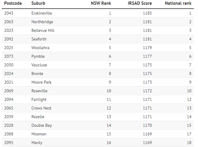
Erskineville, the small inner-west suburb wedged between Bohemian Newtown and the once-industrial area of Alexandria, has emerged as the surprise winner of Australia’s top-ranked postcode, based on a mix of household income, occupation and education measures.
Australian Bureau of Statistics 2021 census data, released on Thursday, reveals that all of the top 10 most socio-economically advantaged postcodes in Australia, and 42 of the top 50, are in Sydney. The eastern suburbs and north shore dominate the top 10, with four postcodes apiece. Melbourne’s top postcode, East Melbourne, comes in at 43.
Sydney’s imaginary latte line, which separates the city along social and economic metrics, remains a powerful divide, but a slew of postcodes are in the process of transforming from working-class areas to more affluent enclaves.

Social researcher Mark McCrindle said Erskineville’s ranking demonstrates that “gentrification and transformation can happen because it was very much a working-class area”, as were some other high-performing locations such as Balmain, Newtown and Surry Hills.
“It might take some decades for that transformation, but it happens,” McCrindle said. “Its location to the city, which used to be a disadvantage because that’s where the tenement homes were, has turned out to be a great advantage.”
Marrickville, Surry Hills and parts of Redfern are all going through that transformation now, following parts of The Rocks and Barangaroo that were once housing commission but are now very much in demand, McCrindle said.
“As public housing is moved to areas that are more affordable for the government to manage and they sell off that public housing, firstly you get higher income earners moving into those areas and as a result of that the area rises up the socio-economic advantage list,” McCrindle said.
Swanky harbourside Woollahra is ranked as the most advantaged council area in Australia.
The least advantaged postcode in the state and second lowest nationally is the Newcastle area of Windale (postcode 2306). The country’s lowest-ranked postcode (4713) is in central Queensland, a place called Woorabinda south-west of Rockhampton.
The least advantaged place in Sydney (for the third census running) is Claymore (2559), which is located in the Campbelltown council area and contains a lot of public housing.

Mount Druitt, Blacktown, St Marys and Penrith are also benefiting from some of the same factors that reshaped Erskineville, McCrindle said, such as proximity to employment hubs like the Norwest business park and the new Western Sydney Aerotropolis.
“Governments are moving away from concentrating public housing in a single area and ‘salt and peppering’ public housing throughout a broader area, which avoids concentrating disadvantage,” he said. “That’s happening now in some of the suburbs of Mount Druitt and it’s rising rapidly.
“Areas of greenfield housing, a long way from anything, without good public transport connections or good connection to employment or other amenities can languish, while those that are better connected to built amenity and public transport will, over time, gentrify.”
Australian National University demographer Dr Liz Allen said the data showed the “stubbornness of inequality across the Sydney region”.

“[The latte line] persists as an invisible ring of privilege that appears to lock out so many deserving Sydneysiders,” she said. “This inequality is a testament to how many Australians have become complacent, even immune, to the experiences of people doing it tougher than themselves.
“Opportunities diminish beyond the inner city; jobs, health, education – it’s the tyranny of distance.”
The weighting and measures used to determine the Index of Relative Socio-economic Advantage and Disadvantage (IRSAD), change at each census, so comparing the economic and social conditions of people and households living in an area over time is not recommended, an ABS spokesman said.
The Sydney areas where the difference between the most and least advantaged are most pronounced are La Perouse, Campbelltown, Maroubra, Coogee, Waterloo, Redfern and Marrickville. Residents in these places may have IRSAD scores up to twice as high as their neighbours.
The 2021 census data lead at the Australian Bureau of Statistics Caroline Deans said their indexes of advantage and disadvantage are based on 23 variables, with the most weight given to income level, type of occupation, employment status and educational attainment.
Researchers have combined Socio-Economic Indexes for Areas (SEIFA) data from previous censuses with other area-based data on topics such as poker machine spending, breastfeeding rates and availability of legal assistance services to gauge levels of advantage.
Deans said it was important to note that the SEIFA data measures an area and can be confounded by a few extremely well-off households living where more people are disadvantaged, and vice versa.
“It’s all about a broader look at the characteristics of an area rather than any one individual household,” she said.


