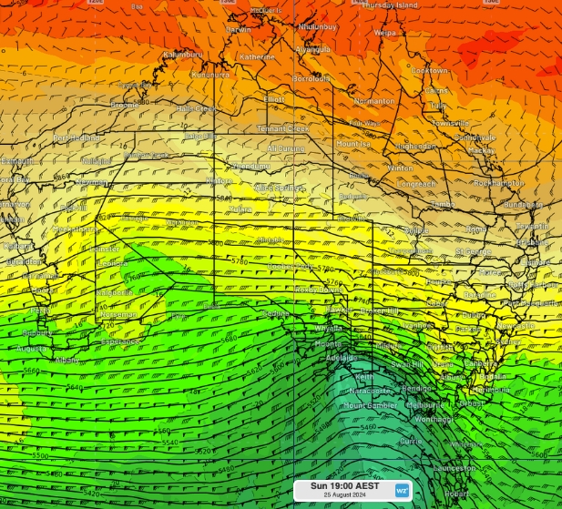
A complex series of troughs and low-pressure systems will deliver rain and possibly severe thunderstorms to every state and territory this week.
One of the first states to see wet weather will be Victoria on Tuesday, right as the Melbourne Cup starts.
The system, spreading from Central Queensland, through western New South Wales and into northern and central Victoria, will bring rain and possible thunderstorms.
‘In Melbourne, it’s going to be a really interesting time for the race as there’s a chance of showers and thunderstorms developing around the start of the Melbourne Cup,’ Weatherzone meteorologist Felix Levesque said.
‘It looks like we’ll see spots of showers and storms developing around 3pm, when the race starts, but the highest chance of thunderstorms will be from 4pm to the early evening.
‘So, the actual race should be on the drier side by people’s celebrations after the race could be ruined by showers moving across the city.’

The rain band stretching from Queensland to Victoria and parts of Tasmania is just one of two systems forecast to cause severe weather across Australia this week.
While the overall forecast for the system over eastern Australia shows low rainfall totals, the area is set to be hit by thunderstorms, causing possibly dangerous conditions, and some isolated regions could receive more than 25mm of rain.
On Tuesday, the only major cities to be affected by the system are Melbourne, with showers and possible storms, and Hobart, with cloudy conditions.
However, that system will begin to spread towards the coast as the week progresses.
‘The eastern trough will being shifting further east bringing possible showers and thunderstorms to Sydney, eastern NSW and eastern Queensland from Thursday into the weekend,’ Mr Levesque said.
Sydneysiders can expect to enjoy sunny conditions until then alongside maximum temperatures in the mid to high 20Cs.
Canberra is looking much greyer with cloudy conditions on Tuesday ahead of a storm on Wednesday as the large system begins moving east.
Once that storm passes, showers are expected to hang over the city through to the weekend.

Brisbane is also forecast to see cloudy weather for the rest of the week before the skies finally clear next Monday.
A second wet weather system over Western Australia is set to begin moving east later in the week.
‘In the west, there is a complex system of troughs and lows from WA extending into the Northern Territory,’ Mr Levesque said.
‘Later in the week, we will see part of that system spread southeast into Adelaide and Melbourne but it will clear by the weekend.
‘Some of that system will remain over northern WA and the NT as the front crosses.’
Cloudy conditions over Perth on Tuesday are expected to clear by Wednesday before returning for the rest of the week.
High temperatures are set to drop in the city on Thursday and Friday from a top of 29C on Wednesday to 24C.
Adelaide will stay mostly sunny this week with clear skies on Tuesday, Thursday and Friday.
The effects of the western system is forecast to trigger cloudy conditions over the weekend.

ADELAIDE
Tuesday Sunny. Max 27
Wednesday Partly cloudy. Min 11 Max 26
Thursday Sunny. Min 12 Max 30
Friday Sunny. Min 17 Max 34
MELBOURNE
Tuesday Shower or two. Possible storm. Max 30
Wednesday Showers. Possible storm. Min 19 Max 29
Thursday Cloudy. Min 15 Max 22
Friday Partly cloudy. Min 13 Max 30
HOBART
Tuesday Partly cloudy. Max 22
Wednesday Showers increasing. Min 12 Max 24
Thursday Shower or two. Min 14 Max 22
Friday Partly cloudy. Min 13 Max 25
CANBERRA
Tuesday Partly cloudy. Max 26
Wednesday Shower or two. Possible storm. Min 10 Max 26
Thursday Showers increasing. Min 11 Max 25
Friday Possible shower. Min 11 Max 29
SYDNEY
Tuesday Mostly sunny. Max 25
Wednesday Mostly sunny. Min 15 Max 27
Thursday Sunny morning. Shower or two. Min 17 Max 28
Friday Possible shower. Min 18 Max 27
BRISBANE
Tuesday Partly cloudy. Max 25
Wednesday Partly cloudy. Min 17 Max 25
Thursday Partly cloudy. Min 16 Max 27
Friday Partly cloudy. Min 18 Max 27
DARWIN
Tuesday Shower or two. Possible storm. Max 34
Wednesday Shower or two. Possible storm. Min 26 Max 33
Thursday Possible shower or storm. Min 26 Max 34
Friday Partly cloudy. Min 26 Max 34
PERTH
Tuesday Cloud clearing. Max 25
Wednesday Sunny. Min 15 Max 29
Thursday Partly cloudy. Min 15 Max 24
Friday Partly cloudy. Min 11 Max 24


